

MUSANDAM
Explore Tours
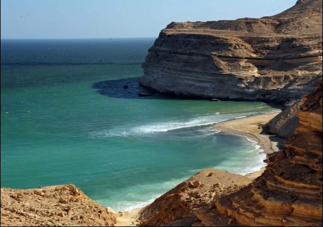
The Musandam Governorate is a mountainous Omani peninsula projecting
into the Strait of Hormuz, separated from the rest of the country by the
United Arab Emirates. Its jagged coastline features for like inlets called
khors, and its waters are home to dolphins and other marine life. Dhow
cruises are a popular activity. In Khasab, the capital, the 17th-century
Khasab Fort houses museum displays.
Musandam Governorate consists of four provinces:
• Khasab, the regional centre of the Governorate
• Bukha
• Dibba Al-Bay’ah
• Madha, itself an exclave, located half-way between the rest of
Musandam and Oman proper.
Included/Exclude
Tour Amenities
Tour Plan
| Time | ACTIVITY |
| 7:00 AM | DEPARTURE |
| 7:00 AM - 8:00 AM | Visit Khasab Fort/ Castle |
| 8:00 AM – 9:00 AM | Enjoy and relax while Dhow cruising |
| 9:00 AM - 1:00 PM | Enjoy and snorkel at Telegraph Island |
| 1:00 PM - 4:00 PM | Drive along the beautiful mountain road with the panoramic view of the lagoon at Khawr Najd |
| 5:00 PM | Back to hotel |
KHASAB FORT / CASTLE:
Khasab (Arabic: صبَ خَ , romanized: Ḫaṣab) is a city in
an exclave of Oman bordering the United Arab Emirates. It is the local
capital of the Musandam Governorate, and has frequently been dubbed the
"Norway of Arabia" because of its extensive fjord-like craggy inlets and
desolate mountain scopes.
Khasab is a small city when compared to nearby cities of the United Arab
Emirates. It has many residents who mostly live in mainland Oman and
come to Khasab for vacations. There is a huge population of Indians,
Pakistanis and Bangladeshis, like in mainland Oman, who work in
restaurants, grocery stores, supermarkets, tour operators and many other
places.
The city is surrounded by the northern mountains of the Western Hajar
Range. Khasab has a fully functional hospital and several hotels, beaches
and parks across the city. The city's population is dominated by ethnic
Omanis from the mainland. Khasab also has a fort which is known as
Khasab Fort. The sea port is dominated by the dhows which take tourists
for a cruise across the natural, dry "fjords".
The city is frequently visited by residents of UAE as the Khasab Coastal
Road provides access to the city from UAE by connecting with the E11
Highway in the UAE side. The city can also be accessed by the ferry which
is maintained by the Government. The ferries are modern.
The Portuguese built Khasab at the beginning of the 17th century, at the
height of their naval presence in the region. The natural harbour gave
shelter from rough seas. Unlike many forts, which were built on high ground
for defensive purposes, Khasab was designed as a supply point for dates
and water for Portuguese ships sailing through the strait. Today, Khasab is
protected from floods by three large dams.
TELEGRAPH ISLAND:
Telegraph Island (also known as Arabic: تليغراف جزيرة, Jazīrat al Maqlab,
and Şaghīr) is located in the Elphinstone Inlet or Khor Ash Sham, the inner
inlet of Khasab Bay, less than 400 meters off the shore of the Musandam
Peninsula, and less than 500 meters south of much larger but also much
lesser known Sham Island, both of which are parts of the Sultanate
of Oman. It is 160 meters long, and up to 90 meters wide, yielding an area
of 1.1 hectares. The name as "Telegraph" comes from the telegraph-cable
repeater station built on the island in 1864.
The inlet at the island is a fjord surrounded by high mountains, with
notable geology in the rock strata which dip downwards under the immense
pressures caused by the Arabian tectonic plate meeting (and subducting
beneath) the Eurasian plate. In the 19th century, it was the location of a
British repeater station used to boost telegraphic messages along
the Persian Gulf submarine cable (see below), which was part of
the London to Karachi telegraphic cable. It was not an easy posting for the
operators, with the severe summer heat and hostility of local tribes making
life extremely uncomfortable. Because of this, the island is, according to
some travel agents and journalists, where the expression "go round the
bend" comes from, a reference to the heat making British officers
desperate to return to civilization, which meant a voyage around the bend
in the Strait of Hormuz back to India.
Today, Telegraph Island is a reminder of the British Empire. Abandoned in
the mid-1870s, the island has remained deserted and only the ruins of the
repeater station and the operators' quarters can be seen. Tourism has
grown in the Persian Gulf region, so the island is regularly visited by dhows
carrying tourists to view the ruins and to fish and snorkel in the waters
around it.
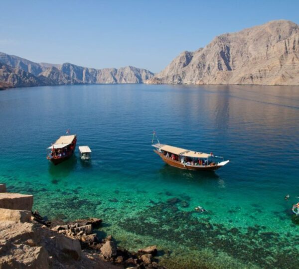
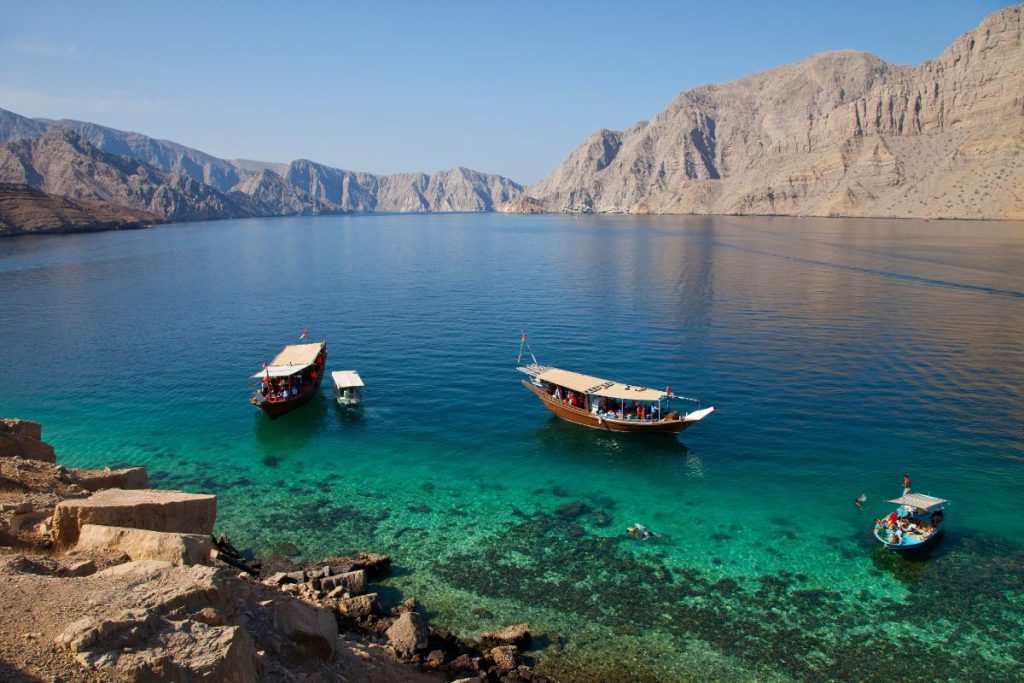
DHOW CRUISE:
Cruise to the Musandam fjords (also known as Khour Shem), beautiful,
calm, turquoise waters contrast with the creamy, white limestone cliffs.
During the cruise we explore small fishing villages (Nadifi, Qana, Maqlab,
Shem, and Seebi) and the famous Telegraph Island and Seebi Island,
there is also a possibility to see dolphins along the way. There will be two
stops for swimming and snorkeling in the clear, dynamic water of
Musandam.
Musandam fjord has much more to entertain you. You will see mountains
and feel like they are painted with a pencil. Small villages in the Khour will
enable you to meet different cultures and amazing people. You will be
surprised to see how they have survived in these small villages. Live on the
edge of Musandam sea and spend their lives fishing in the clear
Musandam waters.
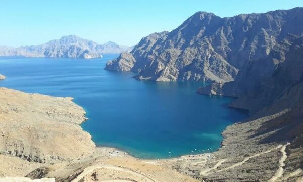
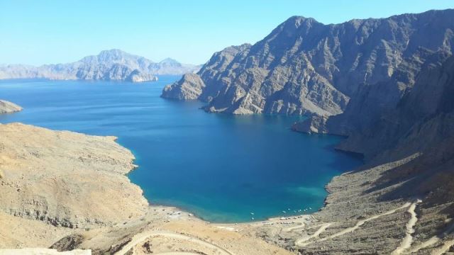
SNORKELLING KHAWR NAJD :
This lagoon is one of the largest in the Governorate of Musandam, and
is from the word ‘help’ in Arabic. At times of distress, travelers and
traders laid up there during bad weather conditions at sea.
Khawr Najd can be reached either by traditional sea vessels (4 hours)
from Khasab through the Strait of Hormuz, or by four-wheel drives
along a beautiful mountain road (30 minutes), overlooking panoramic
views of the lagoon from a height of 420 metres, where the tourist can
revel in majestic scenery of sea and mountain
| Time | ACTIVITY |
| 7:00 AM | DEPARTURE |
| 7:30 AM - 9:30 AM | Take a ride along Jebel Harim and see the magnificent view |
| 9:30 AM – 12:30 NN | Go around and visit villages of Lima and Khumzar |
| 1:00 PM - 5:00 PM | Relax and enjoy at Dibba beach |
| 6:00 PM | Back to hotel |
JEBEL AL HARIM:
Jebel al-Harim “Mountain of Women” is a high mountain pass
at an elevation of 2.087m (6,847ft) above the sea level located in
the Musandam Peninsula of Northern Oman.
The pass, also known as Jebel as-Sayh is the highest mountain in
Musandam. The road to the summit is gravel, rocky and very steep. On the
peak sits – besides a military installation – a telecommunication tower. It's
used for military purposes, so the road doesn't go over the top.
This trail passes through remote areas, so you need to be prepared. This
route is not suitable for normal cars. At this height, temperatures can fall
here at night to freezing point. Be sure to have spare water and tires with
you if you intend to drive to Jebel Al Harim.
The mountain scenery surrounding Musandam Peninsula's highest peak,
Jebel Harim (Mountain of Women), is very striking, with strong striations in
the rock face and spectacular vistas across the arid landscape. In spring,
the scenery softens as a tinge of green touches the mountainside and
delicate blooms such as wild geraniums and miniature iris contrast with the
rugged backdrop. The mountain can be accessed from Khasab via a
graded road (4WD only), which switchbacks through limestone formations
until it reaches the Sayh plateau, a startling patchwork of fields and grazing
donkeys surrounded by stone settlements. The road climbs a further 8km
to a pass below the telecommunications tower (off limits to the public) that
marks the top of the mountain. The pass can also be reached from Wadi
Bih, shared by Oman and the UAE. The whole area makes for a
spectacular off-road day trip.
VILLAGE OF LIMA:
This is a small village separated from Wilayt Khasab in Musandam
Governorate by rugged mountainous peaks. That’s why the best way
to reach this village is by boats that will take you through marine vistas
that will be engraved in your memory for ever. There visitors will enjoy
the fantastic rock formations of the mountain range directly overlooking
the sea, and birds hovering over the sapphire waters through the
distance that separates Khasab from Lima. The village is known for its
local crafts specially the unique AlJarz.
VILLAGE OF KHUMZAR:
Kumzār (Arabic: زارَ مْكُ( , also written as Kumza, is a village located
in Musandam, the northernmost province of Oman.
[1] It is the second most
northerly inhabited part of the country, and the most northerly inhabited part
on its mainland, located on the Strait of Hormuz. The village is isolated and
only accessible by boat.
Kumzar has been inhabited for approximately 500 years, although exact
records are difficult. Early Portuguese maps of the area highlight a
settlement in the area.
The isolated location of the village has harboured a separate
language, Kumzari. The Kumzaris religious practice is based in Islam but
with traditional folk values. The culture is distinct from the
other Arabic settlements in the area.
Fishing is the dominant source of income, tuna and sardines being the
major catch. Most families have two houses, one in Kumzar and the
second in Khasab. The extreme heat in the summer makes Kumzar almost
uninhabitable and from May to September most people leave Kumzar to
stay in Khasab. In Khasab the Kumzari are typically isolationist, having
their own district; which is close to the sea and where all the houses are
grouped.
DIBBA:
It is politically divided into three segments:
• Dibba Al-Fujairah, ruled by the Emirate of Fujairah, UAE
• Dibba Al-Hisn, ruled by the Emirate of Sharjah, UAE
• Dibba Al-Baya, ruled by the Governorate of Musandam, Oman
This large natural harbor on the east coast of the northern Emirates has
been an important site of maritime trade and settlement for millennia,
with relatively recent excavations underpinning the importance of the
town as a site of entrepot trade throughout the Iron Age and into the late
pre-Islamic era.
A collective tomb, discovered by accident in 2004, led to a number of
excavations in the area of the present town which have yielded
evidence of a large settlement with layers of occupation and significant
finds of trade goods, bitumen, ceramics and glass as well as coins.
Three copper alloy tetradrachms were found at the site which, as well as
pottery finds, link it to the Hellenistic period at the major pre-Islamic
cities of Mleiha and Ed-Dur, while Roman amphorae, ceramics and
glass attest to a continuity of not only occupation but a lively regional
trade.
Finds at the site attest to trade links with Bahrain, north-eastern Arabia,
Iran, Mesopotamia and India, while amphorae, terra sigillata, glass and
intaglios demonstrate connections between Dibba and the Roman
Empire - two intaglios found in the town were engraved with figures of
Perseus and Medusa (similar to one found in southern Thailand), further
suggesting an extensive pre-Islamic trade network stretching far to the
East.
Location
Find a route from your location
Related Tours
Review Scores
3 thoughts on “MUSANDAM”
Add a Comment Cancel reply
Booking Tour
Last Minute Deals

Muscat Half-Day Tour OPTION 3

Muscat Half-Day Tour OPTION 2
4.6
This is the best tour on the east coast! It was amazing how many places we visited and what great memories we made!
4
We always stay at here when in town. The location is great, staff is wonderful and we love the overall feel. Beautiful view from the here.
4.2
It is a great place to shop not too far from New York. We took the bus from Port Authority and traveled through the countryside to get there.